About Miyagase Dam
-
General Operation of the Wide-area Water System
Purpose of Integrated Water Management
For effective use of water resources, integrated water management is implemented in collaboration with Sagami Dam and Shiroyama Dam (Kanagawa Prefecture) by way of two channels.
Although the catchment area of Miyagase Dam is smaller than that of Sagami Dam and Shiroyama Dam, the effective storage capacity of Miyagase Dam is about twice that of Sagami Dam and Shiroyama Dam combined. The smaller capacities of both Sagami Dam and Shiroyama Dam mean that their water levels can soon reach their limit, which often leads to wasteful water discharge. By collaborating with Miyagase Dam by way of channels, water is managed effectively along the entire Sagami River System.Area Catchment area (km²) River basin area (km²) Storage capacity (thousand m³) Miyagase Dam Catchment Area 213.9
(101.4)101.4 183,000 Doshi Dam Catchment Area 112.5 112.5 - Sagami Dam and Shiroyama Dam combined catchment area 1,201.3 1,201.3 95,565
(Sagami Dam 48,200)
(Shiroyama Dam 47,365)Role of Channels
The two channels play an important role as facilities necessary for integrated water management.
Doshi Channel
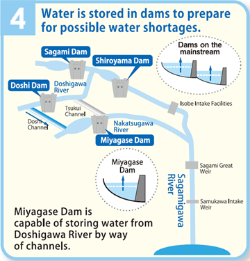
Conducts water from Doshigawa River to Miyagase Dam to maintain sufficient water levels within Miyagase Dam.Tsukui Channel
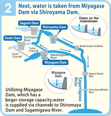
Sends water stored in Miyagase Dam to the upstream of Shiroyama Dam when water levels of dams along the mainstream decrease.-
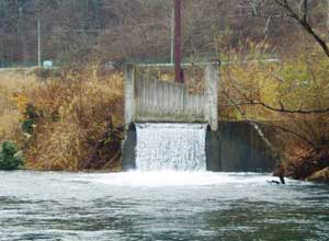 Doshi Channel outlet
-
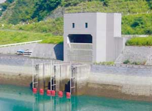 Tsukui Channel intake
Doshi Channel Tsukui Channel Inlet Aone, Tsukui-machi, Sagamihara city, Kanagawa Prefecture Hanbara, Aikawa-machi, Aiko-gun, Kanagawa Prefecture Outlet Toriya, Tsukui-machi, Sagamihara city, Kanagawa Prefecture Aoyama, Tsukui-machi, Sagamihara city, Kanagwa Prefecture Length Approx. 8km Approx. 5km Flow volume 20m³/s (max) 40m³/s (max) Integrated Water Management System
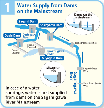
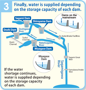
If water levels are such that the river environment and water intake is negatively affected, water is first supplied from dams on the mainstream of Sagamigawa River (Sagami Dam and Shiroyama Dam), followed by Miyagase Dam. If the water shortage is especially severe, water is supplied depending on the storage capacity of each dam.
By implementing integrated water management among Sagami Dam, Shiroyama Dam and Miyagase Dam, a stable water supply to Sagamigawa River can be achieved. -