

About Watarase-yusuichi
-
Contents
Watarase-yusuichi Overview
Japan's largest detention basin
![[Map]Location of Watarase-yusuichi Area](./images/overview_intro_001.png)
When heavy rain causes a sudden surge of water in rivers, detention basins serve to hold back some of the increase to prevent it from rushing downstream. Watarase-yusuichi, which has an area of 33 square kilometers, is located in the northwest of the city of Koga, Ibaraki Prefecture, and straddles four prefectural borders: Ibaraki (Koga), Tochigi (Tochigi, Oyama, and Nogi), Gunma (Itakura), and Saitama (Kazo). Construction on Watarase-yusuichi’s regulating reservoirs, built to provide efficient flood control, began in 1962. There are now three regulating reservoirs: No. 1 Regulating Reservoir, No. 2 Regulating Reservoir, and No. 3 Regulating Reservoir.
Information on Watarase-yusuichi
![[illustration]Shape of Watarase-yusuichi Area](../images/overview_data_002.png)
- Area of Watarase-yusuichi
- Approx. 33km2
- Outer circumference of Watarase-yusuichi
- Approx. 30km
- Gross storage capacity of Watarase-yusuichi
- Approx. 170,000,000m3
- Area of Lake Yanaka
- Approx. 4.5km2
- Gross storage capacity of Lake Yanaka
- Approx. 26,400,000m3
- Area of reed fields
- Approx. 15km2
Chronology(FY denotes fiscal year, which runs from April to March.)
- FY 1910
- The Watarase River is registered as a river controlled by the National Government of Japan. Improvement construction work begins.
- August 1910
- A flood causes significant damage to the Watarase area.
- 1911
- The Tone River Improvement Plan is revised and includes the construction of Watarase-yusuichi.
- FY 1918
- Fujioka Shingawa River, which was constructed by excavating the plateau between the Watarase River and Akama Pond, is opened to water. Most of the major construction work, including the perimeter levee, is completed.
- September 1935
- A flood causes significant damage to the Watarase area.
- June 1938
- A flood causes significant damage to the Watarase area.
- July 1938
- A flood causes significant damage to the Watarase area.
- 1939
- The Tone River Expansion Plan is formulated. The conversion of Watarase-yusuichi into a flood control reservoir is included in the plan.
- September 1947
- Typhoon Kathleen causes significant damage to the Watarase area.
- February 1949
- The Revised Tone River Improvement Plan is formulated.
- April 1965
- In accordance with revisions to the River Law, the Master Plan for the Implementation of River System Construction Works for the Tone River is formulated.
- FY 1970
- The No. 1 Regulating Reservoir begins operations.
- FY 1972
- The No. 2 Regulating Reservoir begins operations.
- FY 1976
- Construction work on the Watarase-yusuichi Integrated Development Project (reservoir creation) begins.
- December 1980
- The Master Plan for the Implementation of River System Construction Works for the Tone River is revised.
- April 1990
- Watarase Reservoir (Lake Yanaka) begins operations.
- April 1991
- The area around Lake Yanaka opens to the public.
- FY 1997
- The River Law is revised. The No. 3 Regulating Reservoir begins operations.
- March 2000
- The Grand Design for the Conservation and Utilization of Nature in Watarase-yusuichi is proposed.
- March 2003
- The Watarase-yusuichi Integrated Development Project is completed.
- February 2006
- The Basic Policy for River Maintenance of the Tone River System is formulated.
- March 2010
- The Basic Plan for Wetland Conservation and Restoration of Watarase-yusuichi is formulated.
- July 2012
- Watarase-yusuichi is registered as a Ramsar site.
- May 2013
- The River Improvement Project for the Tone and Edo Rivers of the Tone River System is formulated.
How the Detention Basin Works
Functions and Roles of Watarase-yusuichi
River Management
Watarase-yusuichi plays an invaluable role in preventing flood damage by temporarily storing water from surging rivers, thus ensuring the safety of both the immediate and metropolitan areas.
-
![[Drawing]Usual](./images/structure_role_01_001.png)
Usual : The basin area is covered with marshes and grasslands.
-
![[Drawing]A flood happens](./images/structure_role_01_002.png)
A flood happens : Water flows into the regulating reservoirs through the overflow levee, reducing the amount of water flowing downstream.
-
![[Drawing]During floods](./images/structure_role_01_003.png)
During floods: The regulating reservoirs hold water until the flooding subsides.
-
![[Drawing]After the flood](./images/structure_role_01_004.png)
After the flood : When the flooding subsides, the drainage gates are opened to allow water to flow out from the regulating reservoirs into the river channel.
- Shui-tei levee
This levee surrounds the entire detention basin area that separates residential areas from the rivers. Its purpose is to prevent water stored in the regulating reservoirs from overflowing into residential areas during a flood.
- Igyo-tei levee
This levee separates the regulating reservoirs from the rivers. The area enclosed by the Igyo-tei levee and the Shui-tei levee is the regulating reservoir.
- Overflow Levee
One section of the Igyo-tei levee is lower than the rest to facilitate the flow of river water into regulating reservoirs when river levels rise. This lower part is called the overflow levee.
- Channel in the reservoir
This conduit allows for the rapid release of water from the regulating reservoir.
Situaiton of the flood
-
![[Photo]Watarase-yusuichi Area as usual](../images/column_flood_001.jpg) Usual
Usual
-
![[Photo]Watarase-yusuichi Area during a flood](../images/column_flood_002.jpg) During floods
During floods
During Typhoon No. 19 (Hagibis) in October 2019, a significant amount of water overflowed from the Watarase River and other waterways and poured into Watarase-yusuichi. Normally, the detention basin is a vast expanse of wetlands, grasslands, and water, however, in the event of flooding, river water rushes over the overflow levee (an area where the levee is slightly lower), reducing the amount of water that flows downriver. In this way, Watarase-yusuichi plays a vital role in protecting the area from flooding.
Water Utilization Functions of Watarase-yusuichi
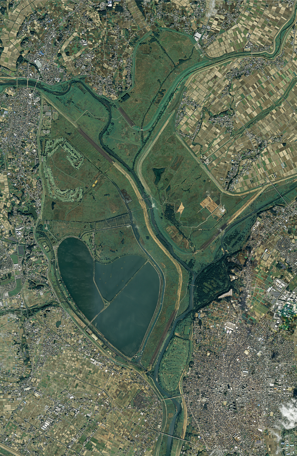
![[Photo]Heart-shaped Lake Yanaka](../images/structure_function_001.jpg)
Watarase Reservoir (Lake Yanaka) is a heart-shaped pond in Watarase-yusuichi. It works in conjunction with dams in the upper reaches of the Tone River to supply water for domestic use to the metropolitan area and to ensure that rivers have an adequate flow of water in times of shortage. In addition, wild-growing reeds are used to improve water quality to ensure that the water supply is of good quality.
Benefits of Watarase Reservoir
![[Drawing]Benefits of Watarase Reservoir](./images/column_benefit_001.png)
Watarase Reservoir is close to the areas being supplied, and water can arrive the same day. Water from dams in the mountains takes approximately two days to arrive.
Water Quality Improvement Measures
![[Photo]Hoshiage (Drying-up) of the Reservoir](../images/column_imp_001.jpg) Hoshiage (Drying-up) of the Reservoir
Hoshiage (Drying-up) of the ReservoirIn winter, the water level of the reservoir is lowered in a process called hoshiage (drying-up). This is done to expose the reservoir bed to sunlight, thereby reducing the proliferation of phytoplankton, which cause a musty smell in early spring. The practice of drying-up started in 2004.
![[Photo]Yata River separator](../images/column_imp_002.jpg) Yata River separator
Yata River separatorThis facility separates the Yata River from the Watarase River near the water intake. It prevents water from the Yata River, which is rich in nitrogen and phosphorus that cause phytoplankton growth, from entering the Watarase Reservoir. The facility began operation in 1999.
![[Photo]Reed Field Purification Facility](../images/column_imp_003.jpg) Reed Field Purification Facility
Reed Field Purification FacilityThis is a facility that purifies the water in the reservoir using the natural purification capabilities of reed beds (Phragmites australis), which grow widely in Watarase-yusuichi. By passing water through the reed beds, nitrogen, phosphorus, and phytoplankton are removed by adsorption, settlement, and absorption. The reed beds, which are becoming increasingly arid, benefit as well, as they become wetlands with the passing water. Ponds and small hills form, creating a diverse environment. Reed-bed purification activities began in 1999.
History of Watarase-yusuichi
Ashio Copper Mine Pollution Incident and the Establishment of Watarase-yusuichi
In the Meiji period (1868–1912), production at the Ashio Copper Mine soared, and a vast number of trees were cut to supply charcoal for smelting. This deforestation, combined with the toxic gas emitted by the smelters and frequent wildfires, resulted in the surrounding mountains losing their ability to retain water. This led to frequent flooding and the spread of mining pollution to the Watarase River and its downstream area. In 1902, as part of measures to prevent further contamination from pollution emanating from the Ashio Copper Mine, a plan was formulated to reduce flood damage by constructing a detention basin in the lower reaches of the Watarase River. In 1922, Watarase-yusuichi was completed.
The Village of Yanaka and Watarase-yusuichi
The area around Watarase-yusuichi was originally a low-lying marshland where the endpoints of the Watarase, Uzuma, and Omoi Rivers intersected. Even after the completion of the detention basin, however, the surrounding area continued to experience severe flooding. To improve the effectiveness of the basin, a project to convert it into regulating reservoirs was launched in 1963. To this end, three regulating reservoir facilities were constructed in the detention basin.
In order to cope with the increasing demand for water that occurred in the early years of the Showa period (1926–1989), a plan was drawn up to create a reservoir in the detention basin. The planned location was the former site of the village of Yanaka, which had been abandoned to construct the detention basin.
At the request of the local community, the remains of the village hall and Raiden Shrine were left standing. The Watarase Reservoir was constructed in the shape of a heart as a result. The reservoir is known to the public as Lake Yanaka.
-
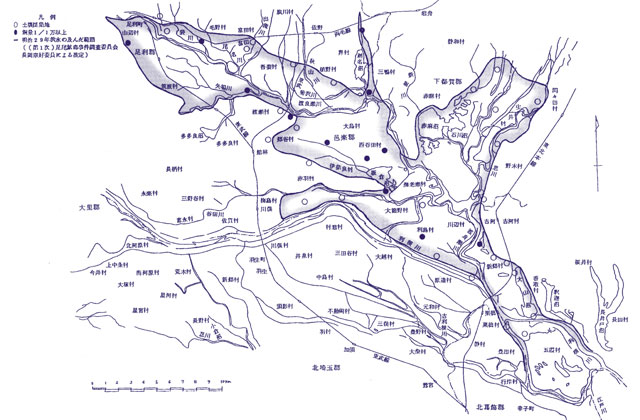
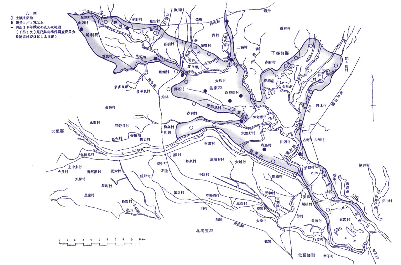
![[Drawing]Outline map of the lower reaches of the Watarase River in the Meiji period](./images/history_yanakamura_001.jpg) Outline map of the lower reaches of the Watarase River in the Meiji period
Outline map of the lower reaches of the Watarase River in the Meiji period
-
![[Photo]上空から見た渡良瀬貯水池(谷中湖)の様子](./images/history_yanakamura_002.jpg) Three flood control facilities and reservoirs
Three flood control facilities and reservoirs
(Lake Yanaka)
Habitat for Diverse Flora and Fauna
About the Ramsar Convention
Introduction to the Ramsar Convention (A Ramsar Convention-registered Wetland in Japan)
![[Drawing]A Ramsar Convention-registered Wetland in Japan](./images/living_ramsar_01_001.png)
The official name of the Ramsar Convention is Convention on Wetlands of International Importance Especially as Waterfowl Habitat. As the convention was adopted at an international conference held in Ramsar, Iran, it is commonly referred to as the Ramsar Convention. The convention aims to promote the conservation and wise use of wetlands, especially those of international importance as habitats for waterfowl, and the flora and fauna that inhabit them.
Watarase-yusuichi, which meets the criteria of a wetland of international importance, has been registered as a Ramsar site since July 2012.
The Three Pillars of the Ramsar Convention
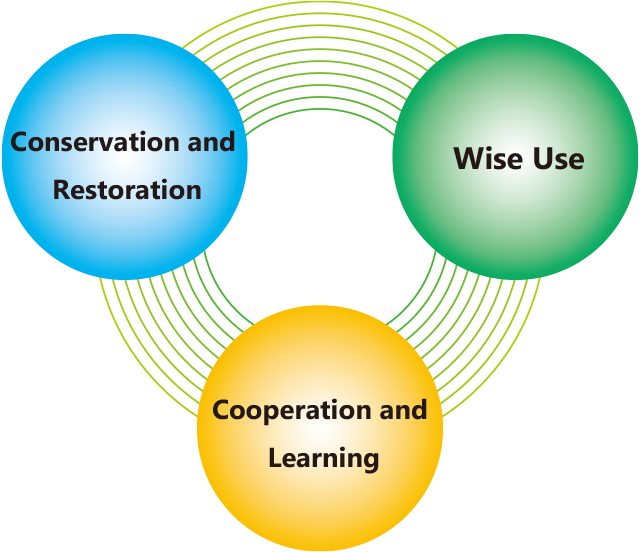
The Ramsar Convention has three fundamental concepts: conservation and restoration of wetlands, the wise use of wetlands, and international cooperation and learning to promote the convention's objectives. In Watarase-yusuichi, initiatives to promote these concepts are being made with the participation of local residents and organizations.
Watarase-yusuichi and Criteria for Registration as a Ramsar Site
Watarase-yusuichi is Japan’s largest wet grassland consisting primarily of reed beds (common reed colonies and Amur silvergrass colonies) south of Hokkaido. It boasts a variety of wetland environments, including the following:
- More than 1,000 plant species grow in the area. Of these, over 50 appear on the Ministry of the Environment's Red List of endangered wildlife species, including tone-hana-yasuri and tachi-sumire.
- Approximately 270 species of birds have been confirmed. From spring to summer, Watarase-yusuichi is a breeding ground for grassland birds such as the Oriental reed warbler, while in winter, it acts as wintering grounds for birds of prey such as the eastern marsh harrier, listed as endangered on the Ministry of the Environment's Red List. It also serves as a roost for swallows and other migratory birds.
Because of its diverse wetland environment, Watarase-yusuichi was registered as a Ramsar Convention site in accordance with Criterion 1: A wetland should be considered internationally important if it contains a representative, rare, or unique example of a natural or near-natural wetland type found within the appropriate biogeographic region. In order to advance the conservation and restoration of Watarase-yusuichi, which originated as part of efforts to improve river management infrastructure, the Basic Plan for Wetland Conservation and Restoration of Watarase-yusuichi (revised edition) was compiled in 2018. Conservation and restoration efforts for the wetland will carry on while taking into consideration the preservation of the existing precious environment as well as the continued improvement of river management infrastructure.
![[Photo]Tone-hana-yasuri](../images/living_ramsar_03_001.jpg) Tone-hana-yasuri
Tone-hana-yasuri![[Photo]Tachi-sumire](../images/living_ramsar_03_002.jpg) Tachi-sumire
Tachi-sumire![[Photo]Eastern marsh harrier](../images/living_ramsar_03_003.jpg) Eastern marsh harrier
Eastern marsh harrier
Diverse Flora and Fauna
- Flora
-
![[Photo]Tachi-sumire](../images/living_ramsar_04_001.jpg) Tachi-sumire
Tachi-sumire![[Photo]Ekisai-zeri](../images/living_ramsar_04_002.jpg) Ekisai-zeri
Ekisai-zeri![[Photo]Hatake-tentsuki](../images/living_ramsar_04_003.jpg) Hatake-tentsuki
Hatake-tentsuki![[Photo]Japanese hardy orchid](../images/living_ramsar_04_004.jpg) Japanese hardy orchid
Japanese hardy orchid![[Photo]Primrose](../images/living_ramsar_04_005.jpg) Primrose
Primrose![[Photo]Thoroughwort](../images/living_ramsar_04_006.jpg) Thoroughwort
Thoroughwort
- Birds
-
![[Photo]Eastern marsh harrier](../images/living_ramsar_04_007.jpg) Eastern marsh harrier
Eastern marsh harrier![[Photo]Hen harrier](../images/living_ramsar_04_009.jpg) Hen harrier
Hen harrier![[Photo]Japanese marsh warbler](../images/living_ramsar_04_010.jpg) Japanese marsh warbler
Japanese marsh warbler![[Photo]Black-winged Stilt](../images/living_ramsar_04_011.jpg) Black-winged Stilt
Black-winged Stilt
Initiatives Related to Conservation and Restoration, Wise Use, and Cooperation and Learning
Conservation and Restoration Initiatives
Wetland Excavation
![[Photo]Watarase-yusuichi’s wetland](../images/effort_care_01_001.jpg)
In order to conserve and restore Watarase-yusuichi’s wetland environment, areas of the wetland that have deteriorated due to aridification or the proliferation of invasive species are excavated. The excavated areas become sites for scientific research and environmental education, while the excavated soil is used to reinforce embankments along the Tone River.
Burning of Reeds
Every year in early spring, 1,500 hectares of land containing dry reeds are burned to promote germination of the wetland's valuable vegetation and to exterminate pests. Young willow trees are also burned, which helps to maintain the area's vast reed beds by preventing against the development of woodlands.
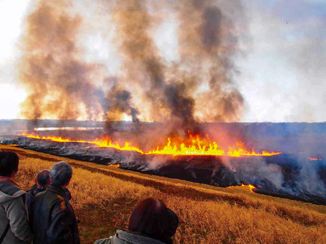 Burning of Reeds
 Areas where land has converted to woodland due to a lack of reed burning
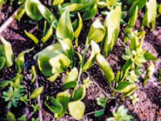 Tone-hana-yasuri maintained by reed burning
Environmental Maintenance by Local Residents and Various Organizations
![[Photo]Environmental Maintenance by Local Residents and Various Organizations](../images/effort_care_03_001.jpg)
To protect the rich natural environment of Watarase-yusuichi, local residents, various groups, NPOs, and other organizations take part in waste collection and the removal of invasive species.
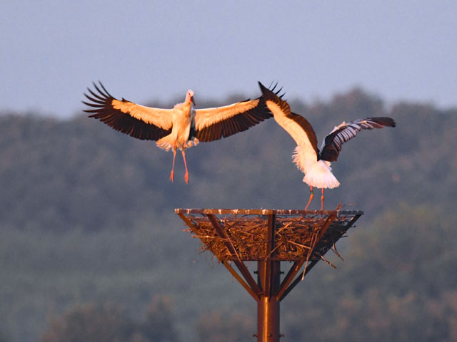
Conservation of Japanese White Stork Habitat
The Japanese white stork, a designated Special Natural Monument, and a bird historically considered auspicious, has an important place in Japanese culture. In Japan, environmental deterioration led to the extinction of wild Japanese white storks in 1971. Since then, young storks have been brought from overseas, and beginning in Hyogo Prefecture in western Japan, efforts have been made to reestablish a wild population through breeding and conservation initiatives.
Japanese white storks were confirmed to have traveled to Watarase-yusuichi in 2014, marking their first migration to the area in 27 years. In 2018, they were found to have settled in the area, using an artificial nest tower as a base. In 2020, chicks were born in that same nest tower to an established pair of storks. With the arrival of the chicks, Watarase-yusuichi became the first river zone in Japan to see the birth of chicks. The presence of Japanese white storks, which are carnivorous but not birds of prey and sit at the top of the wetland ecosystem, is evidence that Watarase-yusuichi has a rich natural environment teeming with wildlife.
Wise Use Initiatives
![[Photo]Making yoshizu](../images/effort_smart_001.jpg)
The wealth of nature found in Watarase-yusuichi are utilized in various ways. For example, the reed beds, among the largest in Japan, play an integral role in the local industry of yoshizu reed-screen manufacturing, while the lake and marshland are used for fishing and other activities.
Cooperation and Learning Activities
![[Photo]activities and environmental learning](../images/effort_study_001.jpg)
Many visitors come to Watarase-yusuichi to participate in environmental learning programs and flora and fauna observation programs that make use of the rich natural environment. In addition, the Taiken Katsudo Center Watarase and related facilities in the area provide information on the uses of the detention basin and the wetland environment. They also support hands-on activities and environmental learning that make use of the detention basin.
![[Drawing]Usual](./images/structure_role_01_001_lg.png)
![[Drawing]A flood happens](./images/structure_role_01_002_lg.png)
![[Drawing]During floods](./images/structure_role_01_003_lg.png)
![[Drawing]After the flood](./images/structure_role_01_004_lg.png)
![[Photo]How the Detention Basin Works](./images/structure_role_02_001_lg.jpg)

![[Photo]Watarase-yusuichi Area as usual](../images/column_flood_001_lg.jpg)
![[Photo]Watarase-yusuichi Area during a flood](../images/column_flood_002_lg.jpg)
![[Drawing]Outline map of the lower reaches of the Watarase River in the Meiji period](./images/history_yanakamura_001_lg.jpg)
![[Photo]上空から見た渡良瀬貯水池(谷中湖)の様子](./images/history_yanakamura_002_lg.jpg)
![[Drawing]A Ramsar Convention-registered Wetland in Japan](./images/living_ramsar_01_001_lg.png)
![[Photo]The Japanese white stork](../images/effort_care_04_001.jpg)