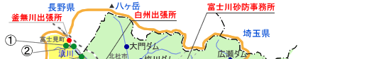
The 1982 Disaster in Pictures
|
The tyhoon damages in 1982
The Damage Reports Caused by the Fearful Typhoon Disasters.
In 1982. Yamanashi prefecture was hit by typhoon No.10 which brought heavy rain and high winds mors severe than the well known typhoon No.7 of 1959. Typhoon No.10 temporarily cut transportation and communication lines which made it a great disaster. However, due to the extensive damage the Fuji River Valley had sustained in typhoon No.7, subsequent flood and erosion control efforts kept the typhoon No.10's death toll and missing persons count to 0, and limited major property damage to only 3 homes.
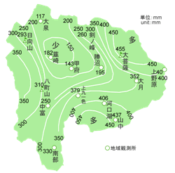
1982-Typhoon No.10 weather conditions
On August 2nd, 1982, before dawn. Typhoon No.10 reached to the Atsumi Peninsula and crosscuts the Japanese Archipelago with high winds and heavy rain. As a result, all of southern Yamanashi Prefecture experienced heavy downpours, landslides and floods. According to the prefectural disaster report of 1982-3, deaths and missing persons from Tyhoon No.10 were 7 individuals, and destroyed 30 homes.
1.The Typhoon's Path
On July 22nd, 1982 at approx. 3 a.m. in the Marshal Islands, a weak tropical depression formed and proceeded west northwest growing as it goes. On 24th, at 3 a.m., it became to develop to Typhoon No.10 over the ocean 1000km south southeast of Minamitori Island. Typhoon No.10 traveled northwest covering 20km/hr and gaining strength along the way. By 9 p.m. on July 29th it reached a point 250km south southeast of Iou Island.
On August 1st, at 12 p.m., form 350km west of Tori Island, Typhoon No.10 gradually changed to a northward heading and moved to north picking up speed. Around 12 a.m. the storm made landfall at the western part of the Atsumi peninsula. The air pressure at the center of the storm at this point is 970 millibars. After landfall at 3 a.m. on August 2nd, typhoon No.10 passed 20km southeast of Takayama city, Gifu Prefecture and went out into the Japan sea around 4 a.m.
2.Rainfall Conditions
1982 -Tyhoon NO.18 Weather Conditions
In the evening of September 12th, 1982 a large and moderately strong Typhoon No.18 was landed near Omaesaki, Shizuoka prefecture. Between 8 and 10 p.m. it traveled across the eastern part of Yamanashi prefecture. As a result, rivers in Yamanashi pref. were flooded and many landslides occurred. According to the Prefectural Disaster Report of 1982-83, deaths and missing persons from Typhoon No.18 was 1 individual, and destroyed 4 home.
1.The Typhoon's Paht
On September 5th 1982 at 9 p.m., a weak tropical depression formed over the ocean southwest of Guam, then proceeded west while gaining strength. By 9 a.m. on September 6th, it became Typhoon No.18 with central air pressure measuring 994 millibars. Tyhoom No.18 then headed northwest while increasing intensity. At 3 a.m. on September 10th, it developed to a large but moderate storm with the central air pressure measured 960 millibars. At 6 p.m. on September 11th, it was at about 640km southwest of Hachijo Island. The central air pressure measured 965 millibars with a top wind speed of 35m/second. The storm area with winds greater than 25m/second extended to 250km in radius. While maintaining its large size and moderate strength, Tyhoon No.18 turned to a northward course, and by 6 p.m. on September 12th it made landfall near Omaezaki, Shizuoka prefecture. After making landfall, the storm weakened gradually. Between 8 and 10 p.m. on September 12th, it passed through the eastern part of Yahamanashi prefecture. At 8 p.m. on 13th, around 100km south of Tomakomai city in Hokkaido, Typhoon No.18 diminished and became an extratropical depression.
2.Rainfall Conditions
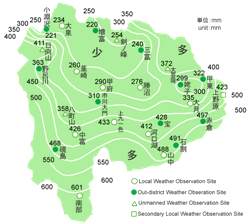
In Yamanashi prefecture light rain started at about 6 a.m. on September 10th due to development of an autumnal rain front positioned over Honshu's southern shore, as the storm movbed north. By 10 a.m. it was raining in the whole region. At about 8 p.m. on September 11th, heavy rain clouds moved north when Typhoon No.18 reached a point over the ocean south of Hachijo Island. At 10:20 p.m. on the same day, a heavy rain and flood warning was issued. Around 6 p.m. on September 12th, a severe rainfalls, 70mm/hr at Nanbu and 23mm/hr at Kawaguchiko Lake, were observed. The total rainfalls from start on 10th to 12 a.m. on 12th were recorded as Nanbu 601mm, Yamanaka 488mm, Kamikuishiki 433mm, Nakatomi 426mm, Uenohara 423mm, Kawaguchiko Lake 412mm, Hinata-yama 411mm, Daibosatsu pass 372mm, Otsuki 335mm, and Kofu 290 mm.
1982 Disaster - Erosion Report
Facts made clear by the erosion and stormflow conditions.
- Compared with the disaster of 1959, the scale of rainfall in the disaster of 1982 was greater.
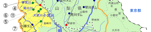
- The drainage areas, which experienced significant amount of runoff soil, were Amahatagawa R., Norogawa R., and Ohmukawa R. All have a large drainage area. On the other hand, the areas, which have a large runoff amount per unit area, were Harukigawa R., Ojiragawa R., and Nigorigawa R. This fact might indicate that devastation of these areas is progressing.
Facts made clear by the dis aster hearing conclusions.
----- Ohmukawa R. & Komukawa R -----
Ohmukawa River
- The 1st floor of Oyabu Hotel with 3-story structure located at the upstream of Ohmukawa R. was completely buried by soil from a mountain behind.
- A dam managed by the prefecture at the upstream of Ohmukawa R. was damaged.
- Trees had fallen across the river. Also, the relative height between the fallen trees and river was significant.
Komukawa River
- The condition around Komukawa R. was severe, and the river shape was completely changed. The area originally with woods became a river with rocks and boulders.
- The counter-dams and sidewalls were missing and wings were destroyed.
- The adjustment effect of the Komukawa No.1 dam was remarkable. The main dam has large culverts at the lower section. The filled sediment was gradually washed away to the lower stream and adjusted by small and medium scale flashfloods followed after.
- The damage against the Komukawa No.2 dam was large.
----- Ojiragawa R., Nagaregawa R., etc -----
- Komukawa R. was the worst affected, but damage to the Ojiragawa R. and Nagaregawa R. was minimal.
----- Main stream of Kamanashigawa R. -----
- The large scouring along the upstream above the Kokkai Bridge was observed. This is introduced as "Mini Grand Canyon" at that time. [1982-83 Disaster Report]
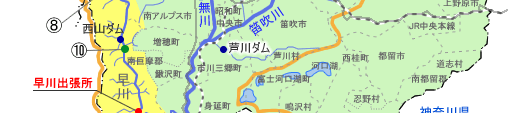
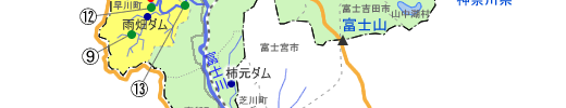
----- Hayakawa R. -----
- The damages were concentrated at mountain streams and their adjacent mountains.
- The riverbed at Inamata valley rose by more than 10m.
- The water level of Hayakawa R. was unusually high compared to Kamanashigawa R.
- The damages at the right and left banks of Norogawa R. were different.
The damages at the right bank were minor because trees on the slopes were not being cut. However, the damages at the left bank were large because many trees were cut to construct the Minamai-Alps service road. So, the all bridges along the service road were destroyed. - The damages around Washizumi mountain were less because trees were not being cut, on the other hand, the damages around Fukasawa were large. The damage level might be related to the road construction.
- The many damages at roads along rivers were observed.
1959 & 1982 Fujikawa River Basin SABO office - Damage Comparison
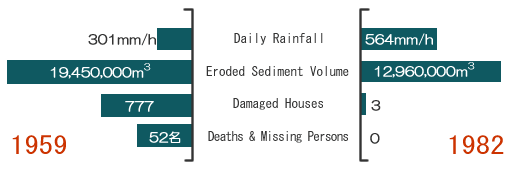
*By maintaining erosion controls, stormflow erosion damage to life and property in 1982 was significantly reduced in the Kamanashigawa R. and Hayakawa R. basins despite twice the amount of rainfall as compared to the 1959 storm.