Fujikawa Branch Office
Steep mountains, geological weakness and frequent debris flow disasters
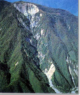
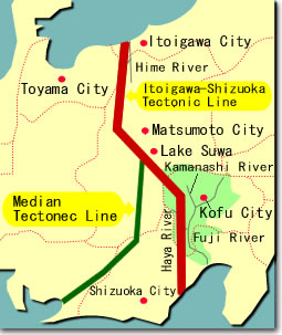
| A large collapse at Mt.Shichimen | Tectonic lines at the Fuji river basin area |
 |
 |
| Due to frequent collapses in the basin, sediment discharge has occured continuously. |
From their water source on the top of the high mountains over 2,000m, the Fuji river and its tributaries flow rapidly eroding riverbanks and riverbeds. Furthermore, the Fuji river basin suffers from its geographical and geological disadvantage, having complex land configuration, various types of strata, numerous faults and geological weakness.
Under these circumstances, the region is susceptible to sediment-related disasters like landslides and debris flows.
The outrage of natural disasters destroying lives and communities
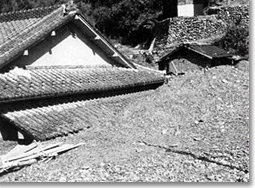
| A house damaged by debris flow |
 |
| 1959 disasters |
| A couple of typhoon in August and September brought about landslides and debris flows which severely destroyed cities, towns and villages of the Fuji river basin area. |
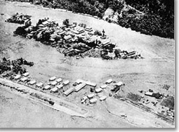
| Hitotsuya area in Nirasaki city isolated by the flooded Kamanashi river |
 |
| 1982 disasters |
Heavy rainfalls brought by a typhoon killed 7 people and destroyed 24 houses in Yamanashi prefecture on August 1st. |
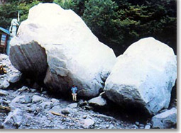
| A huge rock being driven out (approx. 1000t) |
 |
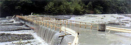
Sabo works contributed to the decrease of damages caused by debris flows in 1982 despite the fact that precipitation doubled compared with 1959. |
| Sediment discharge raised the riverbed by 10m burying a bridge |
 |
Hayakawa Branch Office
| The disaster in 1982, at Amahata area. | The disaster in 1982, after the typhoon No.10, merge area of Haya river and Fuji rivers. |
 |
 |
Comparison of the disaster at the Fujikawa river system in 1959 and 1982
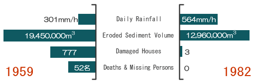
*The rainfall amount in 1982 was nearly double of that in 1959. Due to the construction of sabo facilities, the disaster damage of debris flow was reduced. The damage against lives and properties along the Kamanashi and Haya river area was able to be kept in minimum.

Kamanashigawa Branch Office
Sediment disaster showed furious power.
Due to its steep stream and geologically weak soil along, the Kamanashi river and its tributaries had often caused sediment disaster in the past. Although Sabo constructions have been preventing the disaster these days, we are still under the threaten of sediment disaster as our residential area expands.
The typhoon damages in 1982
| Hot-spring resort facilities destroyed by debris flow (1982) | Sediment outflow from the tributaries (1982) |
 |
 |
| Destroyed street (1982) | Mud stream of the Kamanashi river |
 |
 |
| Ohomukawa bridge being washed away (1982) | |
 |
The typhoon damages in 1959
| A residential area buried by sediments (1959) | Ohmukawa bridge being washed away (1959) |
 |
 |
 Memorial monument built at Tatsuzawa in the Tatsubagawa upper reaches where was destroyed by the typhoon no.7 in 1959.
In Fujimi-cho, the attack of the typhoon no.7 resulted in 18 people killed, 1 missing and 9 injured, and the total damage reached 630 million dollars at that time.
Hakusyu Branch Office
Disaster history (The typhoon damages in 1959 and 1982)
The Five-rivers with plenty of river water runs over steep and fragile area. There were many disasters caused in the long history. As the Shingen-bank was constructed by the Lord Shingen Takeda, this didnt fully protect the area from flooding disasters. Many disasters were recorded in the following Edo period. Another severe disaster occurred in the Meiji period because of unplanned forest felling. Devastation of the rivers heavily promoted after the World War II, causing flooding disasters. In 1959, the area was damaged by a huge disaster recorded in the history. Since then, the preparation of various sabo works were started. The effects of the sabo works, which are to harmonize the nature and mankind, are well appeared. The damage during the typhoon in 1982 was to keep in minimum condition.
| Destroyed left side river bank by the typhoon damage in 1982. | Huge rocks carried by debris flow during the typhoon in 1982. |
 |
 |
Destroyed hotel by the debris flow during the typhoon in 1982.

| Raged Ohmukawa over a village damaging houses. | A flood victim stood with hopeless looking the ruined village. |
 |
 |
| Damage in 1959 | Damage in 1959 |
Hitotsuya area in Nirasaki shi isolated by
the flooded Kamanashi river.

Monument of Chisuikoukyou
 It was constructed on August 14, 1969 at Mukawa village (Mukawa-cho, Hokuto shi that was suffered a most severe damage during the typhoon in 1959.)
Comparison of the disaster at the Fujikawa river system in 1959 and 1982
The sabo works at Fuji river area since the 1959 typhoon disaster was able to control another typhoon damage in 1982 at minimum condition.